|
|
|
|
Chachapoyas: The Architecture of Wonder
|
I stood before the
stern faces gazing sightlessly ahead with the same empty sockets as the kings of Luxor or
the statues of Easter Island. All wear an expression that seems to be saying something we
are still unable to grasp. But we weren't in Egypt, nor some wind-swept Pacific island,
but the Chachapoyas mountain region in northeast Peru. Without realising I trod on the
treacherous edge of the path and sent a stone plummeting in stark silence straight down
into the green depths of the Juscubamba gorge far below. Paling to the colour of my
underwear, I groped shakily for a place to sit, partly to better contemplate the
KarajŪa
sarcophagi and partly to let my heartbeat resume its normal rhythm. Looking at their
position on the top of the abyss, you'd think the people that carved these tombs out of
the bare rock must have had wings. My still-fresh fright had sent my imagination into
overdrive and I had the strange feeling that the dead Sachapuya monarchs had just issued a
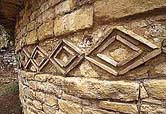
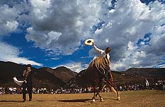
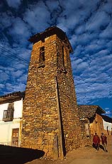
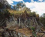
warning, as if to say: What are you doing here, little man? Go back where you belong. "Alvaro, I'll wait for you below," shouted Alejandro, who had finished shooting. His voice brought back the dim Lima morning, when this adventure started. Jorge Chavez Airport. A murky light filtering through the windows and Alejandro's wild look as he waved desperately to me with the plane tickets. "Alvaro! Run! We're going to miss the plane." We sprinted and made it in time to our twin-propeller transport. An hour later Alejandro looked up from his book to see us dropping stuka-like towards a thin black airstrip on the edge of a gaping chasm. The colour only returned to his face when the plane had taxied to a standstill on the tarmac. We would have to get used to this sort of thing because the people in these parts prefer living in the rocky upper reaches of the mountains than in the narrow valleys. Chachapoyas mayor Leonardo Rojas Sanchez met us with a glass of the local firewater called huarapo and, after the mandatory toast, we headed for the town in the company of our guide Martin Chumbe. The normally tranquil streets of Chachapoyas were awash with people, especially the Santo Domingo district, where pacer horses wheeled, couples danced the marinera and everyone looked flushed from exertion and huarapo. We helped ourselves to purtumute, a typical dish (made of boiled maize, beans, coriander and smoked bacon) and later visited the rustic stills where the locals make huarapo. We decided to turn in early because we had a long hike ahead of us the next day. It was a waste of time though, as our eagerness to see the KarajŪa tombs kept sleep at bay until well after midnight. On the trail of the Sachapuyas In the overall scheme of pre-Hispanic cultures it was the Sachapuyas, after the Incas, that left behind the largest - around 500 archaeological sites - and richest architectural legacy. The historian Waldemar Espinoza thinks the Sachapuyas (whose name comes from the quechua words sacha, meaning mountain, and puya, meaning mist, a permanent feature of the area), were a confederacy of small nations united by a political alliance and common cultural traits (language, ceramics, burial customs and a distinct building style). The Sachapuyas were assimilated into the Inca empire by Tupac Inca Yupanqui in 1452. Historian Peter Lerche calculates their population at between 300,000 and 530,000, a number that declined drastically in the aftermath of the Conquest ("more than 90 per cent of the Andean population living in the province of Chachapoyas had disappeared 200 years after contact with the Europeans."). Their language, too, was lost forever. Nevertheless, based on comparative studies of pre-Inca place names in the area, the linguist Paul Rivet concluded that the language had a Caribbean connection, especially with the Chibcha civilisation in Colombia. However, there were things that neither time nor conquest could destroy: the myriad expressions of their art and architecture that crop up at the summit of a hill (Kuťlap), in the heart of the jungle (Gran Pajatťn, Vilaya) and, most astonishing of all, overlooking an abyss: the KarajŪa tombs, which is where we headed the morning after our arrival. What we failed to foresee, however, that the desire to follow the trail of the Sachapuyas would completely alter our plans and we would spend the next few nights roughing it, without returning to Chachapoyas until we were due to leave. With Martin Chumbe leading the way and five gringos from Colorado in tow, we set out from Chachapoyas on the 40-minute car journey to the village of Luya. From there, we turned our back on its whitewashed, tile-roofed houses and began walking. Our route took us through the towns of Corazůn de Jesķs and Huaychopampa, passing maize and alfalfa fields, until we reached the village of Shipata at the mouth of the Juscubamba gorge, where, perched high up on one of the sides - the rockiest, naturally - were the KarajŪa tombs. As, by this stage, we'd already been walking for four hours and MartŪn told us the light would be no good for Alejandro to get any worthwhile shots, we decided that to spend the night in Shipata. With the pressure off, I decided to have a look around. From somewhere in the village the wind carried the sound of a band. It turned out to be the cemetery. The coffin hadn't been covered over with earth yet. Rudimentary crosses struggled here and there to remain upright. The musicians offered me a glass ofyonque, a strong cane spirit the peasants favour. Everybody ate and drank without going overboard but neither was there the solemn formality you encounter in Lima on such occasions. The next day, after finding someone willing to put us up for the night, we would find out how the people here used to honour their dead centuries ago. Villages of stone and straw After recovering from my fright at the tombs of the dead Sachapuya rulers, I made my way down the slope to see Alejandro slouched easily astride a horse. If you hang on to its tail -he said- the climb up to Shipata will be easier. As it turned out, it was. Back in Luya we found the district authority bus waiting to take us to Jalca Grande. We entered the Utcubamba valley, crossing colonial bridges over the lovely green river with stands of tara and molle trees crowding either bank and occasionally coming to pretty villages along the way. One of these was Tingo, where we ran into MartŪn and the five Americans. Sleep well? -he asked. Our yawns and stretching were answer enough. The bus climbed up a steep, twisting side road out of the valley. The first things we saw of Jalca Grande were its high, occasionally conical roofs. The village was built on pre-Hispanic ruins. One corner of the Plaza de Armas is occupied by a stone church built in the 16th century, while on the opposite corner stands a museum that contains among its relics the vestments brought by the original priests, some of which are four hundred years old and embroidered with gold and silver thread. The museum also boasts Sachapuya ceramics and stone utensils among its exhibits. That night we slept under the stars and were up at dawn roaming the ancient village. From the lower end of the village we could clearly make out on top of the mountain on the other side of the valley the imposing ramparts of the Kuťlap fortress. It was time to get a closer look. We went back to the village of Tingo, where the signs of the mudslide that all but destroyed it in 1993 are still evident. If you're fit you can reach Kuťlap after a 4 or 5-hour climb. Our problem was that we had to fly back to Lima the next day, so we drove, taking a route that passes through the villages of Longuita and MarŪa and deposited us at the foot of Kuťlap, at an altitude of 3,000 meters. This magnificent megalithic construction was officially discovered in 1843 by judge Juan Crisůstomo Nieto. His description of the ruins - the dimensions he recorded meant its volume was three times that of the Great Pyramid of Cheops - attracted the attention of several scientists, including Antonio Raimondi (1860), the Swiss geologist Arthur Wertheman (1870- 75), the French explorer Charles Wiener (1881) and the Swiss anthropologist Adolph Bandelier (1893). While Alejandro went to work, I stood in front of a colossal wall 584 meters long by 20 meters high that I first visited years previously. Then I noticed the same ungainly fortress caretaker I had seen back then. His name is Josť Portocarrero and he has been protecting Kuťlap from latter-day invaders for the past eighteen years. The Incas must have had a hard time taking the fortress because there is another enormous wall looms inside the first and the only three entrances narrow progressively the further in you go, until they are only wide enough to accommodate a single person, making the attackers easy meat for the defenders. However, not everything about Kuťlap is monumental; there are circular constructions adorned with friezes showing orchids and trees, giving them an appearance that is at once wild and poetic. On the southern edge is the "Tintero" (meaning inkwell), the inside of which is shaped like a long-necked bottle. Its walls lean outwards at an impossible gravity-defying angle and a face is carved into the stone at the base. Some claim it was an oracle or an observatory, others that it was used for human sacrifices, while the more fanciful say that a jaguar prowled the bottom waiting to be thrown a nice fat enemy. |
By Alvaro Rocha
Volume I/Issue 5, Page 50
Updated
[Top of Page] ![]() http://www.rumbosperu.com
http://www.rumbosperu.com
![[xxx]](../images/issue5/rpag60-s.jpg)
![[xxx]](../images/issue5/rp50-51-s.jpg)